Published
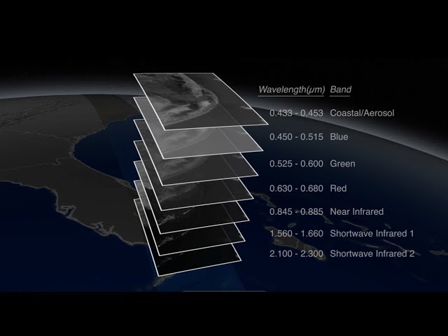
Landsat satellites circle the globe every 99 minutes, collecting data about the land surfaces passing underneath. After 16 days, the Landsat satellite has passed over every spot on the globe, and recorded data in 11 different wavelength regions. The individual wavelength bands can be combined into color images, with different combinations of the 11 bands revealing different information about the condition of the land cover.
The Landsat program is jointly managed by NASA and the USGS:
This video is public domain and can be downloaded at:
Like our videos? Subscribe to NASA's Goddard Shorts HD podcast:
Or find NASA Goddard Space Flight Center on Facebook:
Or find us on Twitter:
The Landsat program is jointly managed by NASA and the USGS:
This video is public domain and can be downloaded at:
Like our videos? Subscribe to NASA's Goddard Shorts HD podcast:
Or find NASA Goddard Space Flight Center on Facebook:
Or find us on Twitter:
- Category
- Social
Be the first to comment
Up Next
Autoplay
-
15:37

Jonathan Van Ness: Honey, She's An Onion With All Sorts Of Layers (Extended Interview)
-
03:11
NASA | Landsat 8 Celebrates First Year in Orbit
-
09:54
How To Make Kek Lapis Sarawak (Layers Cake)
-
03:11
NASA | Landsat Tracks Urban Change and Flood Risk
-
00:47
There's so many layers to this ONE-OF-A-KIND audition! | Auditions | BGT 2023 | #shorts
-
07:36
NASA | Landsat's Global Perspective
-
02:15
Ultimate Garlic Peeling Trick -- How to Peel 20 Cloves in 20 Seconds!
-
17:11
Data Hacking: Data Science for Entrepreneurs: Kevin Novak at TEDxWakeForestU
-
06:10
NASA | Landsat Helps Feed the Birds
-
01:16
NASA | Landsat's Orbit
-
01:42
Landsat: Farming Data From Space
-
58:46
Energy Data: Big Decisions - Miniseries Part 3 of 3: Which Problems to Solve, What Data to Use?
-
11:47
Episode #1003: Peeling Mr. Red Spot
-
02:44
Joe Manganiello Peels Back Layers & Clothes of Real Life Strippers
-
04:35
How to Deal with Peeling Skin
-
03:28
Layers Of Atmosphere | The Dr. Binocs Show | Educational Videos For Kids
-
03:54
How to Heal Dry Peeling Skin on Face
-
03:57
Layers Of Soil - The Dr. Binocs Show | Best Learning Videos For Kids | Peekaboo Kidz
-
00:43
Lock Layers Are The Key To Success! Here's Why. ????????????
-
00:21
The Secret to Peeling Eggs in Seconds!
-
03:45
NASA | When Trees Fall, Landsat Maps Them
-
01:57
NASA | Landsat Looks to the Moon
-
20:06
Peeling Pogo and Stuffing a Krait
-
04:13
How to Get Rid of Peeling Skin after Sunburn