Published
On July 23rd, 1972, the first Landsat spacecraft launched into orbit. At the time, it was called "Earth Resources Technology Satellite," or ERTS, and was the first satellite to use a scanning spectrophotometer. Previous satellites relied on film cameras (ejecting the exposed film to be caught by planes) or transmitted the signal from television cameras. The scanning sensor and its successor sensors on subsequent Landsat satellites revolutionized how we study our home planet.
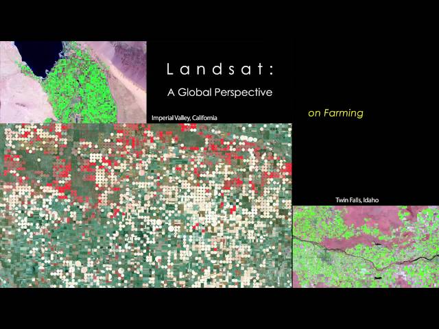
Celebrating this anniversary, this video is a "greatest hits" montage of Landsat data. Throughout the decades, Landsat satellites have given us a detailed view of the changes to Earth's land surface. By collecting data in multiple wavelength regions, including thermal infrared wavelengths, the Landsat fleet has allowed us to study natural disasters, urban change, water quality and water usage, agriculture development, glaciers and ice sheets, and forest health.
NASA and the U.S. Department of the Interior through the U.S. Geological Survey (USGS) jointly manage Landsat, and the USGS preserves a more than 40-year archive of Landsat data that is freely available over the Internet.
This video is public domain and can be downloaded at:
Like our videos? Subscribe to NASA's Goddard Shorts HD podcast:
Or find NASA Goddard Space Flight Center on facebook:
Or find us on Twitter:
Be the first to comment
Up Next
Autoplay
-
07:43

NASA | MAVEN: NASA's Next Mission to Mars
-
03:11
NASA | Landsat 8 Celebrates First Year in Orbit
-
03:59
NASA | Webb's Backplane Pathfinder Arrives at NASA JSC for Cryotesting
-
03:56
NASA | NASA Ve las Luces de Festividades desde el Espacio
-
02:32
NASA | Global Hawks Soar into Storms
-
02:57
NASA | Peeling Back Landsat's Layers of Data
-
00:31
NASA | 2014 Continues Long-Term Global Warming
-
00:29
He Warned NASA To Stop The Challenger's Doomed Launch #Disaster #NASA #Challenger
-
01:19
Landsat Tracks Mount St. Helens Recovery
-
01:57
NASA | Landsat Looks to the Moon
-
03:12
NASA | Muppet Lola and NASA Engineers Promote Science Education in Latin America
-
01:32
NASA | Aquarius Returns Global Maps of Soil Moisture
-
06:10
NASA | Landsat Helps Feed the Birds
-
00:52
Landsat's Global View of Ice Velocity
-
02:57
Who Works At NASA? What It Means To Be a NASA Employee
-
03:45
NASA | When Trees Fall, Landsat Maps Them
-
01:16
NASA | Landsat's Orbit
-
03:11
NASA | Landsat Tracks Urban Change and Flood Risk
-
01:42
Landsat: Farming Data From Space
-
01:54
NASA | First Global Rainfall and Snowfall Map from New Mission
-
01:31
Landsat Celebrates 45 Years of Earth Observations
-
02:05
NASA | Ask A Climate Scientist - Extreme Weather and Global Warming
-
04:29
NASA | NASA Sees Holiday Lights from Space
-
00:52
Landsat's Global View of Ice Velocity