Published
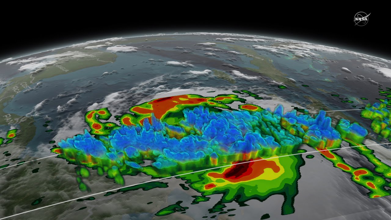
NASA’s Precipitation Measurement Missions' GPM core satellite captured Hurricane Matthew in 3-D as it made landfall on Haiti and as it traveled up to the Florida coast.
The Global Precipitation Measurement Mission or GPM flew directly over the storm several times between October 2 - October 6, 2016. The view on October 6 reveals massive amounts of rainfall being produced by the storm as it approaches Florida.
The GPM core satellite carries two instruments that show the location and intensity of rain and snow, which defines a crucial part of the storm structure – and how it will behave. The GPM Microwave Imager sees through the tops of clouds to observe how much and where precipitation occurs, and the Dual-frequency Precipitation Radar observes precise details of precipitation in 3-dimensions.
Credit: NASA's Goddard Space Flight Center/Joy Ng
Music: Diamond Skies by Andrew Skeet [PRS], Anthony Phillips [PRS] from the KillerTracks catalog
For more information:
This video is public domain and along with other supporting visualizations can be downloaded from the Scientific Visualization Studio at:
If you liked this video, subscribe to the NASA Goddard YouTube channel:
Or subscribe to NASA’s Goddard Shorts HD Podcast:
Follow NASA’s Goddard Space Flight Center
· Facebook:
· Twitter
· Flickr
· Instagram
· Google+
The Global Precipitation Measurement Mission or GPM flew directly over the storm several times between October 2 - October 6, 2016. The view on October 6 reveals massive amounts of rainfall being produced by the storm as it approaches Florida.
The GPM core satellite carries two instruments that show the location and intensity of rain and snow, which defines a crucial part of the storm structure – and how it will behave. The GPM Microwave Imager sees through the tops of clouds to observe how much and where precipitation occurs, and the Dual-frequency Precipitation Radar observes precise details of precipitation in 3-dimensions.
Credit: NASA's Goddard Space Flight Center/Joy Ng
Music: Diamond Skies by Andrew Skeet [PRS], Anthony Phillips [PRS] from the KillerTracks catalog
For more information:
This video is public domain and along with other supporting visualizations can be downloaded from the Scientific Visualization Studio at:
If you liked this video, subscribe to the NASA Goddard YouTube channel:
Or subscribe to NASA’s Goddard Shorts HD Podcast:
Follow NASA’s Goddard Space Flight Center
· Facebook:
· Flickr
· Google+
- Category
- Documentary
- Tags
- NASA
Be the first to comment
Up Next
Autoplay
-
01:14

NASA | 15-year Satellite Record Shows Decline in N. Hemisphere Phytoplankton Populations
-
00:44
NASA's 3D View Shows Hurricane Matthew's Intensity
-
02:10
NASA's MMS Captures Magnetic Reconnection in Action
-
00:38
NASA | Seeing Inside A Hurricane
-
01:46
NASA Set To Launch Shoebox-sized Satellite Studying Earth's Upper Atmosphere
-
01:15
NASA Captures Hurricane Harvey's Rainfall
-
02:38
NASA Has Eyes On The Atlantic Hurricane Season
-
01:48
NASA | Building the Nation's Newest Weather Satellite
-
03:08
A New Multi-dimensional View of a Hurricane
-
02:38
NASA Has Eyes On The Atlantic Hurricane Season
-
01:03
New NASA Satellite Reveals Profiles of Ice, Forests and Oceans
-
03:54
NASA | Teaming Up to Test the Future of Satellite Refueling
-
01:23
NASA Peers Inside Hurricane Edouard
-
03:34
NASA’s New View of the Daily Cycle of Rain
-
02:05
NASA's SDO Captures Mercury Transit Time-lapse
-
02:14
NASA | Satellite Tracks Saharan Dust to Amazon in 3-D
-
04:38
How America's First Satellite Helped Create NASA
-
01:54
NASA | A View From The Other Side
-
02:19
NASA | RXTE Satellite Catches the Beat of a Midsize Black Hole
-
00:29
NASA Releases a Tiny Satellite to Study Ice Clouds
-
02:24
NASA's Fermi Satellite Celebrates 10 Years of Discoveries
-
01:33
NASA | GPM's Stormy New View
-
02:00
NASA's Fermi Satellite Clocks a 'Cannonball' Pulsar
-
00:53
NASA | Satellite Shows High Productivity From U.S. Corn Belt